Aerial UAV—Control Survey
The Aerial UAV is to ensure the accuracy of aerial triangulation and determine the absolute position of objects in space. In the conventional low altitude digital aerial photogrammetry external specification, the layout of control points is specified in detail, which is the basis for ensuring the accuracy of large scale mapping. The technique of oblique photograph requires higher image overlap than traditional photography, and the requirement of image control point layout is not suitable for high resolution unmanned aerial UAV oblique photogrammetry. Aerial UAV usually adopts GPS positioning mode, and has POS data itself. It plays a significant role in determining the relative position between images, and can improve the accuracy of empty three computation.
1 Conventional three-dimensional modeling
Based on the Smart 3D algorithm, a control interval can be provided from the angle of the final aerial triangulation feature point-cloud. The proposed value is to set a control point at every 20000~40000 pixels, in which the difference POS data (relatively accurate initial value) can be relaxed to 40000 pixels, and at least 20000 pixels of the differential POS data are set. At the same time, it should be applied flexibly according to the actual terrain and terrain conditions of each task, such as very large terrain undulating, large area vegetation and surface water features very few, and need to increase the control point. The measurement of control points adopts attached traverse measurement to get high-precision location information.
2 Safeguard of emergency surveying and mapping
After the earthquake, landslides, debris flow and other natural disasters, in order to obtain the disaster area's three-dimensional data, we can not control the measurement according to the traditional operation mode. By reading the coordinates of the Google map, the handed GPS measurement, and the RTK measurement, the few control points of the disaster area can be quickly obtained, and the real three-dimensional model of the disaster area can be generated to provide assistance for post-disaster relief.
3 The selection requirements of point location
The target image of the image control point should be clear, and select the place where the spot is easy to be identified, is fixed and easy to measure.When the condition is available, we can make the mark point of the control point of the field work first, usually choose the white (or red) paint to mark the cross sign, and test several images before the aerial photography to ensure that the cross sign can be correctly identified on the oblique image. After the control point measurement is completed, it is necessary to make the control point distribution map in time, control the spot information table, accurately describe the location and position information of each control point, and facilitate the use of the internal pricking points.
Hot Products
Industry drone T2


Personne à contacter : flying titan, +75 5 21 53 90 34
Bonne affaire : acheter au vendeur
Nous vous invitons à lire nos conditions générales d'utilisations. Vous pouvez aussi vous rendre sur nos FAQ et consulter notre page d'informations sur les risques liés à la contrefaçon.
|
Cette page concerne les importateurs et exportateurs de Aerial UAV—Control Survey Rechercher dans la catégorie : Informatique Rechercher dans la catégorie : uav—control, aerial, survey |
Signalez un abus
Vendredi 21 novembre 2014
Quantité : 1 UNIT - Prix : 1,5 USD
Nous avons été la fabrication de rouleaux à peinture depuis 10 ans dans nos usines à Konya et d'Istanbul. Nos rouleaux de peinture sont classées en trois types selon l'application que tout peut être utilisé pour les deux peintures à base d'eau et de solvants des peintures à base...
TURKON EXPORT LTD.
- 42050 - KONYA
- +905353265862
Signalez un abus
Jeudi 10 juillet 2025
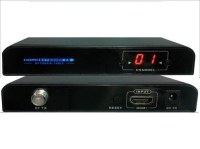
▲VE-30RFM RX (Front / Rear) ▲VE-30RFM TX (Front / Rear) VE-30RFM HDMI to RF Matrix Extender is designed to convert HDMI signal to HD digital TV signal based on DVB-T CATV signal, it uses 64QAM mode to realize the HD digital TV signal conversion and transmit via coaxial cables for...
Meicheng Audio Video Co., Ltd.
- meicheng
- 23511 - New Taipei City
- 886 2 82280311
Signalez un abus
Jeudi 01 août 2013
Quantité : moq:1pcs - Prix : USD1553.9
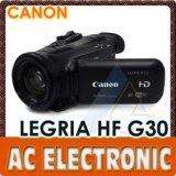
The Canon LEGRIA HF G30 Full HD Camcorder shoots 1920 x 1080p Full HD video at 50 fps in either AVCHD or web-friendly MP4 format. It also supports Native 25p Progressive Mode recording, which will give your footage a more cinematic look. You can use built-in Cinema-Looks Filters...
AC Electronic Ltd
- 999077 - HongKong
- +85 2 23 25 18 67
- +86 13501567844
Paiement sécurisé